Digitalization of indoor navigation helps to reduce operational costs and costs on wayfinding (printed signs, kiosks, special signs etc.). It’s relevant for many industries, including facility management, healthcare, transportation, manufacturing, warehouse management, retail and many more. The indoor positioning and indoor navigation (IPIN) uses sensor technologies, magnetic positioning and low energy Bluetooth (BLE) to provide orientation services in different locations.
It can be named a critical technology in several industries. Imagine that you are in a hospital, where one of the most asked questions and interruptions for hospital staff is “sorry, can you help me?”. Staff is often busy with critical tasks and they need to stop their routine or urgent health-related tasks and literally take you by hand and guide you to the destination. Poor wayfinding in critical locations leads to complaints, frustration and even violent reaction from visitors. So no wonder the indoor positioning and indoor navigation market have grown in the last couple of years.
To keep up to date and be competitive, companies offering navigation and positioning solutions and services have to improve their services, as well as find new ways to create better and cheaper maps.
The best solution is to use crowdsourcing technology. We’ll share our experience of applying 3D mapping crowdsourcing, explain how it helps indoor navigation and positioning.
Creating digital twin for indoor navigation
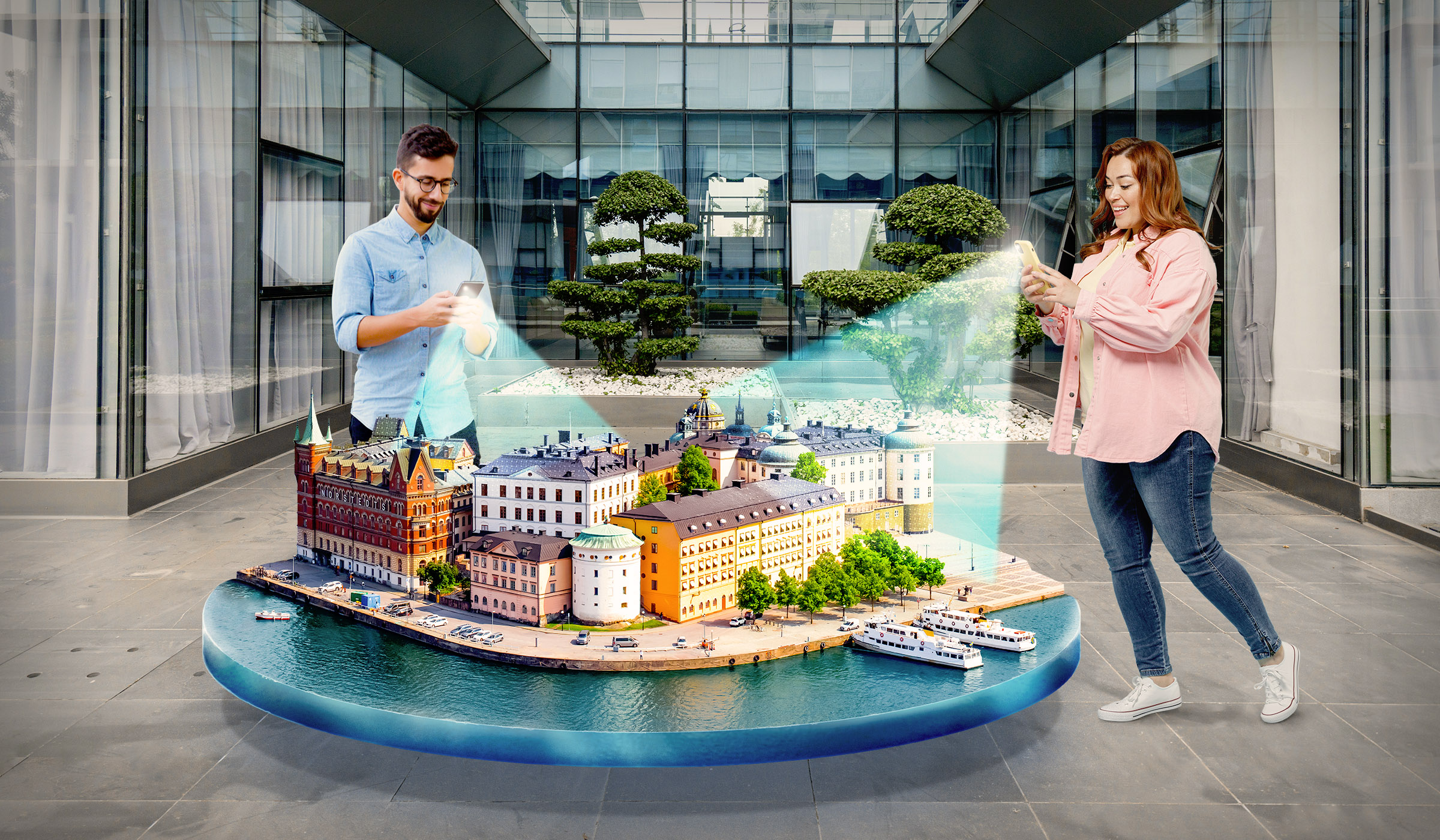
Digital twins (3D map of facility, room or any other object) enable navigation-related services to precisely mark points of interest and add digitally augmented reality content to the environment as well as embrace location-based advertising, interactive room tours, etc. An important feature of the digital twin is that information from the sensors of a real device operating in parallel is used to set input influences on it. There are alternative options for sensors. For example, the Augmented Pixels solution works on the mobile phone and updates the map (when already created) even with the simple use of indoor navigation (when the camera is on).
The better the digital map the better and the precise navigation is. Correct navigation allows you not only to set up the correct movement around the location but also to combine it with inventory management, meeting rooms and desk booking software if needed.
To ensure AR content relevancy and high navigation accuracy, it’s important to keep digital twins up to date. The user must constantly update the map, especially taking into account the changing interior decorations, including new furniture and equipment, rearrangement or renovation.
Previously, digital twins creation required complex expensive devices and specially trained people who can handle the mapping process. In this case, 3D mapping and even map updates take a lot of resources. However, recently mobile mapping appeared on the market and keeps growing fast because of its simplicity and effectiveness. Mobile 3D mapping is replacing the traditional complex way of creating digital twins.
This technology is rapidly spreading across industries, including aerospace, retail, healthcare and other sectors, according to research from Deloitte. According to the report, the global market for digital twin technologies will reach $16 billion by 2023, while the market turnover of technologies that form the basis for this progress (in particular, IoT and machine learning) should grow significantly.
Value of mobile 3D mapping
The increase in smartphone users is spurring other industries and technologies. One of these technologies is a 3D map, created by any user using a mobile phone. Mobile 3D mapping makes digital creation much easier and cheaper. It enables the creation of a digital twin with affordable devices (smartphone, tablet, AR glasses etc.) as almost 70% of the world’s population have smartphones. Anybody can learn how to create a 3D digital twin very fast.
It enables companies to apply a crowdsourcing approach. With the help of mobile 3D mapping, every company can save significant costs on digital twins on equipment, professionals who handle this process, vendors etc.
Crowdsourcing approach
Back in 2007, Google conducted an interesting experiment. Residents of Indian cities received free GPS devices and the task to mark the coordinates of all significant objects they pass by in the city. If the information came from several sources, the object was mapped. So in a short time, rather detailed maps of cities were compiled, indicating transport stops, attractions, restaurants, municipal facilities and other buildings. The OpenStreetMap service works on the same principle.
The availability of this technology allows generating large 3D maps, the creation of which would previously take a huge amount of time and resources.
Crowdsourcing technology helps to make the whole process even more effective, faster and cheaper. An example of applying the crowdsourcing approach for 3D mapping is our 3D map crowdsourcing platform GlobalMap.AI. Anyone can create a 3D map of the location and submit it to us in exchange for cash or GlobalMap coins. The user base and movement of 3D mapping enthusiasts called Global Mappers.
Creating 3D maps with mobile gives many advantages compared to traditional 3D mapping. Crowdsourcing technology saves costs on 3d mapping because you don’t need extra high-skilled and high-paid staff, to buy extra complex devices, to spend your resources on map updates.
3D map crowdsourcing in private facilities
The crowdsourcing of precise 3D maps can be carried out in private offices of companies, regardless of size and industry. The technology is applicable in offices, shopping malls, hospitals, secure locations etc.
Instead of ordering digital twin creation from contractors or hiring professionals, your employees can create 3D maps with just a mobile phone, room by room. The map will be updated while using the navigation in the facility (when the camera is turned on), so you won’t need to spend any extra time and money on map updates.
For example, a facility management professional needs to create a 3D map of workspaces with the location of equipment, furniture, or goods in a warehouse. Now he doesn’t need special equipment, a subscription to an expensive service from a leading vendor and special training. Everything can be done with a smartphone. Only administrators have access to 3D maps, so you can be sure of higher security. The whole map is not available for navigation users (visitors, staff), they can see only the navigation route and their position at the location.
Conclusion
There’s a direct relationship between 3D mapping (digital twins) and IPIN products. Previously, digital twins creation required complex expensive devices and specially trained people who can handle the mapping process. In this case, 3D mapping and even map updates take a lot of resources. However, recently mobile mapping appeared on the market and keeps growing fast because of its simplicity and effectiveness. Mobile 3D mapping is replacing the traditional complex way of creating digital twins.
3D map crowdsourcing is the future of the spatial mapping industry. If we talk about the pros for businesses, it decreases expenses on digital twins and mapping devices for indoor navigation and indoor positioning software providers, offers higher security and real-time map updates.